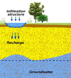
Infiltration basins are vegetated depressions designed to hold runoff from impervious surfaces, allow the settling of sediments and associated pollutants, and allow water to infiltrate into underlying soils and groundwater. Infiltration basins are dry except in periods of heavy rainfall, and may serve other functions (e.g. recreation). They provide runoff storage and flow control as part of a SuDS ‘train’. Storage is provided through landscaped areas that allow temporary ponding on the land surface, with the stored water allowed to infiltrate into the soil. The measure enhances the natural ability of the soil to drain water by providing a large surface area in contact with the surrounding soil, through which water can pass.
Infiltration basins may also act as “bioretention areas” of shallow landscaped depressions, typically under-drained and relying on engineered soils, vegetation and filtration to reduce runoff and remove pollution. They provide water quality benefits through physical filtration to remove solids/trap sediment, adsorption to the surrounding soil or biochemical degradation of pollutants. Water quality is, however, a key consideration with respect to infiltration basins as the potential for the infiltration to act as a vector for poor quality water to enter groundwater may be high. Pre-treatment may be required in certain areas before infiltration techniques are appropriate for use, for example swales or detention basins to reduce sediment loading and retain heavy metals and oils.
Infiltration basins have the potential to provide ancillary amenity benefits. They are idea for use as playing fields, recreational areas or public open space. They can be planted with trees, shrubs and other plants, improving their visual appearance and providing habitats for wildlife. They increase soil moisture content and help to recharge groundwater, thereby mitigating the problems of low river flows.
Explicative scheme of the MAR principle
Source: Andras Kis’ presentation, NWRM Workshop 1
| Benefits | Level |
|---|---|
|
ES1 - Water storage
|
Medium
|
|
ES3 - Natural biomass production
|
Low
|
|
ES4 - Biodiversity preservation
|
Medium
|
|
ES5 - Climate change adaptation and mitigation
|
Medium
|
|
ES6 - Groundwater/aquifer recharge
|
High
|
|
ES7 - Flood risk reduction
|
High
|
|
ES8 - Erosion/sediment control
|
Low
|
|
ES9 - Filtration of pollutants
|
High
|
|
ES10 - Recreational opportunities
|
Medium
|
|
ES11 - Aesthetic/cultural value
|
Medium
|
|
PO2 - Improving status of physico-chemical quality elements
|
Low
|
|
PO4 - Improving chemical status and priority substances
|
Low
|
|
PO5 - Improving quantitative status
|
Medium
|
|
PO7 - Prevent surface water status deterioration
|
Medium
|
|
PO8 - Prevent groundwater status deterioration
|
Low
|
|
PO9 - Take adequate and co-ordinated measures to reduce flood risks
|
High
|
|
PO11 - Better protection for ecosystems and more use of Green Infrastructure
|
High
|
|
PO12 - More sustainable agriculture and forestry
|
Low
|
|
PO14 - Prevention of biodiversity loss
|
Medium
|
|
BP1 - Store runoff
|
High
|
|
BP2 - Slow runoff
|
High
|
|
BP5 - Increase evapotranspiration
|
Low
|
|
BP6 - Increase infiltration and/or groundwater recharge
|
High
|
|
BP7 - Increase soil water retention
|
Low
|
|
BP9 - Intercept pollution pathways
|
High
|
|
BP10 - Reduce erosion and/or sediment delivery
|
Medium
|
|
BP14 - Create terrestrial habitats
|
Medium
|
|
BP16 - Reduce peak temperature
|
Low
|
|
BP17 - Absorb and/or retain CO2
|
Low
|