Headwaters are the source areas for rivers and streams, crucial for sustaining the structure, function, productivity and complexity of downstream ecosystems. They are vital to hydrologic cycling as they are one of the main areas where precipitation contributes to surface and groundwater. Headwaters are typically less intensively used than downstream areas. In many headwater areas, extensive agriculture, forests or other semi-natural land cover types predominate. Forests in headwater areas have a beneficial role for water quantity and quality. Creating or maintaining forest cover in headwater catchments is a widely used practice in many major cities including New York, Istanbul and Singapore, as these cities are reliant on headwater forests for drinking water provisioning. Forest soils generally have better infiltration capacity than other land cover types and may act as a “sponge”, slowly releasing rainfall. In areas of high relief, afforestation of headwater catchments can contribute to slope stabilization and may reduce the risks associated with landslides. On the other hand, afforestation of headwaters in dry areas may lead to reduction of water yield.
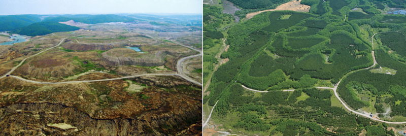
Before and after afforestation
| Benefits | Level |
|---|---|
|
BP1 - Store runoff
|
High
|
|
BP2 - Slow runoff
|
High
|
|
BP5 - Increase evapotranspiration
|
High
|
|
BP6 - Increase infiltration and/or groundwater recharge
|
High
|
|
BP7 - Increase soil water retention
|
High
|
|
BP8 - Reduce pollutant sources
|
High
|
|
BP9 - Intercept pollution pathways
|
High
|
|
BP10 - Reduce erosion and/or sediment delivery
|
High
|
|
BP11 - Improve soils
|
Medium
|
|
BP12 - Create aquatic habitat
|
Medium
|
|
BP13 - Create riparian habitat
|
Medium
|
|
BP14 - Create terrestrial habitats
|
High
|
|
BP15 - Enhance precipitation
|
Low
|
|
BP16 - Reduce peak temperature
|
Medium
|
|
BP17 - Absorb and/or retain CO2
|
High
|
|
ES1 - Water storage
|
High
|
|
ES2 - Fish stocks and recruiting
|
Low
|
|
ES3 - Natural biomass production
|
High
|
|
ES4 - Biodiversity preservation
|
Medium
|
|
ES5 - Climate change adaptation and mitigation
|
High
|
|
ES6 - Groundwater/aquifer recharge
|
High
|
|
ES7 - Flood risk reduction
|
High
|
|
ES8 - Erosion/sediment control
|
High
|
|
ES9 - Filtration of pollutants
|
High
|
|
ES10 - Recreational opportunities
|
High
|
|
ES11 - Aesthetic/cultural value
|
High
|
|
PO1 - Improving status of biology quality elements
|
Low
|
|
PO2 - Improving status of physico-chemical quality elements
|
Low
|
|
PO3 - Improving status of hydromorphology quality elements
|
Low
|
|
PO4 - Improving chemical status and priority substances
|
Low
|
|
PO5 - Improving quantitative status
|
Medium
|
|
PO6 - Improving chemical status
|
Medium
|
|
PO7 - Prevent surface water status deterioration
|
Medium
|
|
PO8 - Prevent groundwater status deterioration
|
High
|
|
PO9 - Take adequate and co-ordinated measures to reduce flood risks
|
High
|
|
PO10 - Protection of important habitats
|
High
|
|
PO11 - Better protection for ecosystems and more use of Green Infrastructure
|
High
|
|
PO12 - More sustainable agriculture and forestry
|
Medium
|
|
PO13 - Better management of fish stocks
|
Medium
|
|
PO14 - Prevention of biodiversity loss
|
High
|