Controlled Drainage

Code
A14
Sector
Agriculture
Year of Issue
2024
Summary

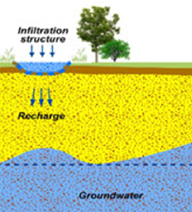
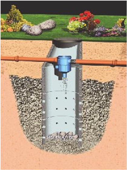
The process of managing the drainage volume and water table elevation by regulating the flow from a surface or subsurface agricultural drainage system.

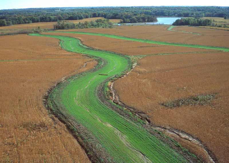
Controlled drainage, also known as drainage water management, is the practice of using a water control structure to raise the depth of the drainage outlet, holding water in the field during periods when drainage is not needed. Unlike conventional free-draining systems...

Possible benefits with level
Benefits Level
BP7 - Increase soil water retention
High
BP9 - Intercept pollution pathways
Medium

Mulching

Code
A13
Sector
Agriculture
Other sector(s)
Urban
Forest
The complete description of the NWRM
Summary

A mulch is a layer of material applied to the surface of an area of soil. Its purpose is any or all of the following:

·       to conserve moisture

·       to improve the fertility and health of the soil

·       to reduce weed growth

·       to enhance the visual appeal of the area

Mulching...

Possible benefits with level
Benefits Level
BP2 - Slow runoff
High
BP6 - Increase infiltration and/or groundwater recharge
Low
BP7 - Increase soil water retention
Medium
BP10 - Reduce erosion and/or sediment delivery
Medium
ES6 - Groundwater/aquifer recharge
Medium
ES7 - Flood risk reduction
Medium
PO5 - Improving quantitative status
Low
PO8 - Prevent groundwater status deterioration
Low
PO9 - Take adequate and co-ordinated measures to reduce flood risks
Medium

'Water sensitive' driving

Code
F07
Sector
Forest
Other sector(s)
Agriculture
Hydro Morphology
The complete description of the NWRM
Summary

Off road driving has potentially severe negative consequences for water quality. Some of these damages can be minimized or mitigated if drivers of vehicles exercise a few simple precautions. Avoiding driving in wet areas whenever possible will limit soil compaction and rutting. Rutting can concentrate flow paths and lead to increased erosion. In colder regions of Europe, driving on frozen soils will also reduce the potential for compaction...

Water sensitive driving would avoid areas such as the one illustrated

Source: Gebhard Schueler’s presentation, NWRM Workshop 1


Water sensitive driving with low pressure tyres and additionnal rolling pathways

Source: https://www.sydved.se/skogsbruk/miljo-och-naturvard/mark-och-vatten/sa-…

Possible benefits with level
Benefits Level
BP2 - Slow runoff
Low
BP6 - Increase infiltration and/or groundwater recharge
Low
BP7 - Increase soil water retention
Low
BP8 - Reduce pollutant sources
High
BP9 - Intercept pollution pathways
Medium
BP10 - Reduce erosion and/or sediment delivery
High
BP11 - Improve soils
Low
BP17 - Absorb and/or retain CO2
Low
ES2 - Fish stocks and recruiting
High
ES4 - Biodiversity preservation
High
ES7 - Flood risk reduction
Low
ES8 - Erosion/sediment control
High
ES9 - Filtration of pollutants
Medium
ES11 - Aesthetic/cultural value
Medium
PO1 - Improving status of biology quality elements
Medium
PO2 - Improving status of physico-chemical quality elements
Medium
PO4 - Improving chemical status and priority substances
Medium
PO7 - Prevent surface water status deterioration
High
PO8 - Prevent groundwater status deterioration
Medium
PO9 - Take adequate and co-ordinated measures to reduce flood risks
Low
PO10 - Protection of important habitats
Low
PO11 - Better protection for ecosystems and more use of Green Infrastructure
Low
PO12 - More sustainable agriculture and forestry
High
PO13 - Better management of fish stocks
Medium
PO14 - Prevention of biodiversity loss
Low

Sediment capture ponds

Code
F09
Sector
Forest
Other sector(s)
Agriculture
Urban
Hydro Morphology
The complete description of the NWRM
Summary

Sediment capture ponds are engineered ponds placed in networks of forest ditches to slow the velocity of water and cause the deposition of suspended materials. Sediment capture ponds are most useful for managing the effects of ditch construction and maintenance, road work and final feeling. While used primarily in forests, sediment capture ponds may be a useful temporary measure for preserving water quality in and around construction sites or...

Sediment capture pond, Slovakia

Source: Michal Kravcík’s presentation, NWRM Workshop 1 (Slovakia)


Possible benefits with level
Benefits Level
BP1 - Store runoff
Medium
BP2 - Slow runoff
Medium
BP3 - Store river water
Low
BP4 - Slow river water
Low
BP6 - Increase infiltration and/or groundwater recharge
Low
BP7 - Increase soil water retention
Low
BP8 - Reduce pollutant sources
High
BP9 - Intercept pollution pathways
High
BP10 - Reduce erosion and/or sediment delivery
High
BP12 - Create aquatic habitat
Low
ES1 - Water storage
Medium
ES2 - Fish stocks and recruiting
High
ES4 - Biodiversity preservation
High
ES5 - Climate change adaptation and mitigation
Low
ES6 - Groundwater/aquifer recharge
Low
ES7 - Flood risk reduction
Medium
ES8 - Erosion/sediment control
High
ES9 - Filtration of pollutants
High
PO1 - Improving status of biology quality elements
Low
PO2 - Improving status of physico-chemical quality elements
Low
PO3 - Improving status of hydromorphology quality elements
Low
PO4 - Improving chemical status and priority substances
Low
PO7 - Prevent surface water status deterioration
High
PO9 - Take adequate and co-ordinated measures to reduce flood risks
Low
PO10 - Protection of important habitats
Low
PO11 - Better protection for ecosystems and more use of Green Infrastructure
Medium
PO12 - More sustainable agriculture and forestry
High
PO13 - Better management of fish stocks
Medium
PO14 - Prevention of biodiversity loss
Medium

Coarse woody debris

Code
F10
Sector
Forest
Other sector(s)
Agriculture
Urban
Hydro Morphology
The complete description of the NWRM
Summary

Coarse woody debris in stream channels has multiple ecological and hydrologic benefits. Coarse woody debris consists of large sections of deadfall: tree stems or stumps that either fall into or are deliberately placed in streams. Coarse woody debris can be deployed with varying degrees of naturalness. At one extreme, coarse woody debris can be used to form coffer or placer dams which effectively limit water flow. At the other extreme, natural...

Possible benefits with level
Benefits Level
BP3 - Store river water
Low
BP4 - Slow river water
High
BP10 - Reduce erosion and/or sediment delivery
Low
BP12 - Create aquatic habitat
High
BP13 - Create riparian habitat
Medium
ES2 - Fish stocks and recruiting
High
ES4 - Biodiversity preservation
High
ES7 - Flood risk reduction
Medium
ES8 - Erosion/sediment control
Low
ES10 - Recreational opportunities
Medium
PO1 - Improving status of biology quality elements
Medium
PO9 - Take adequate and co-ordinated measures to reduce flood risks
Medium
PO10 - Protection of important habitats
Medium
PO11 - Better protection for ecosystems and more use of Green Infrastructure
Medium
PO13 - Better management of fish stocks
Medium
PO14 - Prevention of biodiversity loss
Medium

Infiltration basins

Code
U12
Sector
Urban
Other sector(s)
Agriculture
Forest
Hydro Morphology
The complete description of the NWRM
Summary

Infiltration basins are vegetated depressions designed to hold runoff from impervious surfaces, allow the settling of sediments and associated pollutants, and allow water to infiltrate into underlying soils and groundwater. Infiltration basins are dry except in periods of heavy rainfall, and may serve other functions (e.g. recreation). They provide runoff storage and flow control as part of a SuDS ‘train’. Storage is provided through...

Explicative scheme of the MAR principle

Source: Andras Kis’ presentation, NWRM Workshop 1


Possible benefits with level
Benefits Level
ES1 - Water storage
Medium
ES3 - Natural biomass production
Low
ES4 - Biodiversity preservation
Medium
ES5 - Climate change adaptation and mitigation
Medium
ES6 - Groundwater/aquifer recharge
High
ES7 - Flood risk reduction
High
ES8 - Erosion/sediment control
Low
ES9 - Filtration of pollutants
High
ES10 - Recreational opportunities
Medium
ES11 - Aesthetic/cultural value
Medium
PO2 - Improving status of physico-chemical quality elements
Low
PO4 - Improving chemical status and priority substances
Low
PO5 - Improving quantitative status
Medium
PO7 - Prevent surface water status deterioration
Medium
PO8 - Prevent groundwater status deterioration
Low
PO9 - Take adequate and co-ordinated measures to reduce flood risks
High
PO11 - Better protection for ecosystems and more use of Green Infrastructure
High
PO12 - More sustainable agriculture and forestry
Low
PO14 - Prevention of biodiversity loss
Medium
BP1 - Store runoff
High
BP2 - Slow runoff
High
BP5 - Increase evapotranspiration
Low
BP6 - Increase infiltration and/or groundwater recharge
High
BP7 - Increase soil water retention
Low
BP9 - Intercept pollution pathways
High
BP10 - Reduce erosion and/or sediment delivery
Medium
BP14 - Create terrestrial habitats
Medium
BP16 - Reduce peak temperature
Low
BP17 - Absorb and/or retain CO2
Low

Retention Ponds

Code
U11
Sector
Urban
Other sector(s)
Agriculture
Forest
Hydro Morphology
The complete description of the NWRM
Summary

Retention ponds are ponds or pools designed with additional storage capacity to attenuate surface runoff during rainfall events.  They consist of a permanent pond area with landscaped banks and surroundings to provide additional storage capacity during rainfall events.  They are created by using an existing natural depression, by excavating a new depression, or by constructing embankments.  Existing natural...

Possible benefits with level
Benefits Level
ES1 - Water storage
Medium
ES3 - Natural biomass production
Medium
ES4 - Biodiversity preservation
High
ES5 - Climate change adaptation and mitigation
Medium
ES7 - Flood risk reduction
High
ES8 - Erosion/sediment control
Medium
ES9 - Filtration of pollutants
High
ES10 - Recreational opportunities
Medium
ES11 - Aesthetic/cultural value
High
PO2 - Improving status of physico-chemical quality elements
Low
PO4 - Improving chemical status and priority substances
Low
PO7 - Prevent surface water status deterioration
Medium
PO9 - Take adequate and co-ordinated measures to reduce flood risks
High
PO11 - Better protection for ecosystems and more use of Green Infrastructure
High
PO12 - More sustainable agriculture and forestry
Low
PO14 - Prevention of biodiversity loss
High
BP1 - Store runoff
High
BP2 - Slow runoff
High
BP5 - Increase evapotranspiration
Medium
BP8 - Reduce pollutant sources
Low
BP9 - Intercept pollution pathways
High
BP10 - Reduce erosion and/or sediment delivery
High
BP12 - Create aquatic habitat
High
BP13 - Create riparian habitat
Medium
BP14 - Create terrestrial habitats
Low
BP15 - Enhance precipitation
Low
BP16 - Reduce peak temperature
Low

Filter Strips

Code
U06
Sector
Urban
Other sector(s)
Agriculture
The complete description of the NWRM
Summary

Filter strips are uniformly graded, gently sloping, vegetated strips of land that provide opportunities for slow conveyance and (commonly) infiltration. They are designed to accept runoff as overland sheet flow from upstream development and often lie between a hard-surfaced area and a receiving stream, surface water collection, treatment or disposal system.

Filter strips are generally planted with grass or other dense vegetation to...

Small filter strip in urban area

Source: Andras Kis’ presentation, NWRM Workshop 1

Filter strip in agriculture area

Source: http://www.nrcs.usda.gov/Internet/FSE_MEDIA/nrcs144p2_021118.jpg

Possible benefits with level
Benefits Level
ES3 - Natural biomass production
Low
ES4 - Biodiversity preservation
Medium
ES5 - Climate change adaptation and mitigation
Low
ES6 - Groundwater/aquifer recharge
Low
ES7 - Flood risk reduction
Low
ES8 - Erosion/sediment control
Medium
ES9 - Filtration of pollutants
High
ES11 - Aesthetic/cultural value
Medium
PO2 - Improving status of physico-chemical quality elements
Low
PO4 - Improving chemical status and priority substances
Low
PO7 - Prevent surface water status deterioration
Medium
PO9 - Take adequate and co-ordinated measures to reduce flood risks
Low
PO11 - Better protection for ecosystems and more use of Green Infrastructure
Medium
PO12 - More sustainable agriculture and forestry
Low
PO14 - Prevention of biodiversity loss
Medium
BP2 - Slow runoff
Low
BP6 - Increase infiltration and/or groundwater recharge
Low
BP7 - Increase soil water retention
Low
BP9 - Intercept pollution pathways
High
BP10 - Reduce erosion and/or sediment delivery
High
BP14 - Create terrestrial habitats
Medium
BP16 - Reduce peak temperature
Low
BP17 - Absorb and/or retain CO2
Low

Soakaways

Code
U07
Sector
Urban
Other sector(s)
Agriculture
The complete description of the NWRM
Summary

Soakaways are buried chambers that store surface water and allow it to soak into the ground. They are typically square or circular excavations either filled with rubble or lined with brickwork, pre-cast concrete or polyethylene rings/perforated storage structures surrounded by granular backfill. The supporting structure and backfill can be substituted by modular, geocellular units. 

Soakaways provide storm water attenuation, and...

Principle of a soakaway

Source: Andras Kis’ presentation, NWRM Workshop 1


Possible benefits with level
Benefits Level
ES1 - Water storage
Low
ES5 - Climate change adaptation and mitigation
Low
ES6 - Groundwater/aquifer recharge
High
ES7 - Flood risk reduction
High
ES9 - Filtration of pollutants
Low
PO2 - Improving status of physico-chemical quality elements
Low
PO4 - Improving chemical status and priority substances
Low
PO5 - Improving quantitative status
Medium
PO7 - Prevent surface water status deterioration
Low
PO8 - Prevent groundwater status deterioration
Low
PO9 - Take adequate and co-ordinated measures to reduce flood risks
High
PO11 - Better protection for ecosystems and more use of Green Infrastructure
Low
BP1 - Store runoff
Medium
BP6 - Increase infiltration and/or groundwater recharge
High
BP7 - Increase soil water retention
Low
BP8 - Reduce pollutant sources
Low
BP9 - Intercept pollution pathways
Low

Swales

Code
U04
Sector
Urban
Other sector(s)
Agriculture
The complete description of the NWRM
Summary

Swales are broad, shallow, linear vegetated channels which can store or convey surface water (reducing runoff rates and volumes) and remove pollutants. They can be used as conveyance features to pass the runoff to the next stage of the SuDS treatment train and can be designed to promote infiltration where soil and groundwater conditions allow. Three kinds of swale give different surface water management capabilities:

  • Standard...

Swale

Source: Andras Kis’ presentation, NWRM Workshop 1


Possible benefits with level
Benefits Level
ES1 - Water storage
Low
ES3 - Natural biomass production
Low
ES4 - Biodiversity preservation
Medium
ES5 - Climate change adaptation and mitigation
Medium
ES6 - Groundwater/aquifer recharge
Medium
ES7 - Flood risk reduction
Medium
ES8 - Erosion/sediment control
Low
ES9 - Filtration of pollutants
Medium
ES11 - Aesthetic/cultural value
Medium
PO2 - Improving status of physico-chemical quality elements
Low
PO4 - Improving chemical status and priority substances
Low
PO5 - Improving quantitative status
Low
PO7 - Prevent surface water status deterioration
Medium
PO8 - Prevent groundwater status deterioration
Low
PO9 - Take adequate and co-ordinated measures to reduce flood risks
High
PO11 - Better protection for ecosystems and more use of Green Infrastructure
Medium
PO12 - More sustainable agriculture and forestry
Low
PO14 - Prevention of biodiversity loss
Medium
BP1 - Store runoff
Medium
BP2 - Slow runoff
High
BP5 - Increase evapotranspiration
Medium
BP6 - Increase infiltration and/or groundwater recharge
Medium
BP7 - Increase soil water retention
Low
BP8 - Reduce pollutant sources
Low
BP9 - Intercept pollution pathways
Medium
BP10 - Reduce erosion and/or sediment delivery
Medium
BP13 - Create riparian habitat
Low
BP14 - Create terrestrial habitats
Low
BP16 - Reduce peak temperature
Low
BP17 - Absorb and/or retain CO2
Low