Mulching
Code
A13
Sector
Agriculture
Other sector(s)
Urban
Forest
The complete description of the NWRM
Summary
A mulch is a layer of material applied to the surface of an area of soil. Its purpose is any or all of the following:
· to conserve moisture
· to improve the fertility and health of the soil
· to reduce weed growth
· to enhance the visual appeal of the area
Mulching...
 |
 |
 |
|
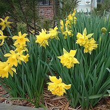
Mulching in urban garden |
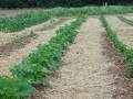
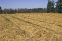
Mulching in agriculture |
|
Possible benefits with level
| Benefits | Level |
|---|---|
|
BP2 - Slow runoff
|
High
|
|
BP6 - Increase infiltration and/or groundwater recharge
|
Low
|
|
BP7 - Increase soil water retention
|
Medium
|
|
BP10 - Reduce erosion and/or sediment delivery
|
Medium
|
|
ES6 - Groundwater/aquifer recharge
|
Medium
|
|
ES7 - Flood risk reduction
|
Medium
|
|
PO5 - Improving quantitative status
|
Low
|
|
PO8 - Prevent groundwater status deterioration
|
Low
|
|
PO9 - Take adequate and co-ordinated measures to reduce flood risks
|
Medium
|


