Infiltration Trenches

Code
U08
Sector
Urban
The complete description of the NWRM
Summary

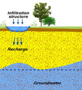
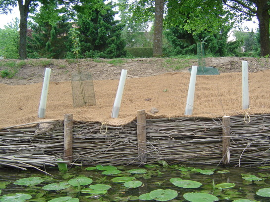
Infiltration trenches are shallow excavations filled with rubble or stone. They allow water to infiltrate into the surrounding soils from the bottom and sides of the trench, enhancing the natural ability of the soil to drain water.  Ideally they should receive lateral inflow from an adjacent impermeable surface, but point source inflows may be acceptable with some design adaptation (effectively they are a form of soakaway).

...

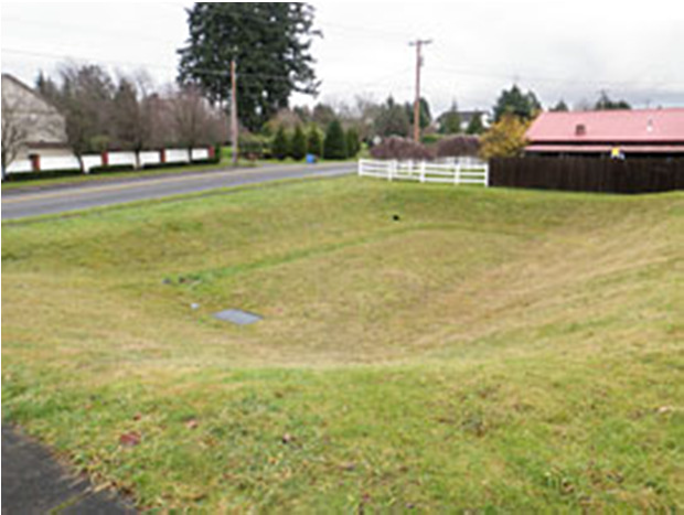
Infiltration trenches with stones in urban area

Source: Andras Kis’ presentation, NWRM Workshop 1

Infiltration trenches in agriculture area

Source: UNDP 2008 (http://www.sswm.info/category/implementation-tools/water-sources/hardware/precipitation-harvesting/field-trenches)

Possible benefits with level
Benefits Level
ES1 - Water storage
Low
ES5 - Climate change adaptation and mitigation
Low
ES6 - Groundwater/aquifer recharge
High
ES7 - Flood risk reduction
High
ES8 - Erosion/sediment control
Low
ES9 - Filtration of pollutants
Medium
ES11 - Aesthetic/cultural value
Low
PO2 - Improving status of physico-chemical quality elements
Low
PO4 - Improving chemical status and priority substances
Low
PO5 - Improving quantitative status
Medium
PO7 - Prevent surface water status deterioration
Low
PO8 - Prevent groundwater status deterioration
Low
PO9 - Take adequate and co-ordinated measures to reduce flood risks
High
PO11 - Better protection for ecosystems and more use of Green Infrastructure
Low
PO12 - More sustainable agriculture and forestry
Low
BP1 - Store runoff
Medium
BP2 - Slow runoff
Low
BP6 - Increase infiltration and/or groundwater recharge
High
BP7 - Increase soil water retention
Low
BP9 - Intercept pollution pathways
Medium
BP10 - Reduce erosion and/or sediment delivery
Medium

Rain Gardens

Code
U09
Sector
Urban
The complete description of the NWRM
Summary

Rain gardens are small-scale vegetated gardens used for storage and infiltration. The term ‘rain garden’ is often used interchangeably with ‘bioretention area’ (although the latter could also be applied more loosely to other measures such as filter strips or swales).

Rain gardens are typically applied at a property level and close to buildings, for example to capture and infiltrate roof drainage. They use a range of components,...

Rain garden

Source: Andras Kis’ presentation, NWRM Workshop 1

Possible benefits with level
Benefits Level
ES1 - Water storage
Low
ES3 - Natural biomass production
Low
ES4 - Biodiversity preservation
Medium
ES5 - Climate change adaptation and mitigation
Medium
ES6 - Groundwater/aquifer recharge
Medium
ES7 - Flood risk reduction
High
ES8 - Erosion/sediment control
Low
ES9 - Filtration of pollutants
Medium
ES10 - Recreational opportunities
Medium
ES11 - Aesthetic/cultural value
Medium
PO2 - Improving status of physico-chemical quality elements
Low
PO4 - Improving chemical status and priority substances
Low
PO5 - Improving quantitative status
Medium
PO7 - Prevent surface water status deterioration
Medium
PO8 - Prevent groundwater status deterioration
Low
PO9 - Take adequate and co-ordinated measures to reduce flood risks
High
PO11 - Better protection for ecosystems and more use of Green Infrastructure
High
PO14 - Prevention of biodiversity loss
Medium
BP1 - Store runoff
Medium
BP2 - Slow runoff
Medium
BP5 - Increase evapotranspiration
High
BP6 - Increase infiltration and/or groundwater recharge
High
BP7 - Increase soil water retention
Low
BP8 - Reduce pollutant sources
Low
BP9 - Intercept pollution pathways
Medium
BP10 - Reduce erosion and/or sediment delivery
Medium
BP14 - Create terrestrial habitats
High
BP16 - Reduce peak temperature
Medium
BP17 - Absorb and/or retain CO2
Low

Detention Basins

Code
U10
Sector
Urban
Other sector(s)
Agriculture
Forest
Hydro Morphology
The complete description of the NWRM
Summary

Detention basins are vegetated depressions designed to hold runoff from impermeable surfaces and allow the settling of sediments and associated pollutants. Stored water may be slowly drained to a nearby watercourse, using an outlet control structure to control the flow rate. Detention basins do not generally allow infiltration: see U12 for infiltration basins.

Detention basins can provide water...

Infiltration basin

Source: Andras Kis’ presentation, NWRM Workshop 1


Possible benefits with level
Benefits Level
ES1 - Water storage
Medium
ES3 - Natural biomass production
Low
ES4 - Biodiversity preservation
Medium
ES5 - Climate change adaptation and mitigation
Medium
ES6 - Groundwater/aquifer recharge
Low
ES7 - Flood risk reduction
High
ES8 - Erosion/sediment control
Medium
ES9 - Filtration of pollutants
Medium
ES10 - Recreational opportunities
Medium
ES11 - Aesthetic/cultural value
Medium
PO2 - Improving status of physico-chemical quality elements
Low
PO4 - Improving chemical status and priority substances
Low
PO7 - Prevent surface water status deterioration
Medium
PO9 - Take adequate and co-ordinated measures to reduce flood risks
High
PO11 - Better protection for ecosystems and more use of Green Infrastructure
High
PO12 - More sustainable agriculture and forestry
Low
PO14 - Prevention of biodiversity loss
Medium
BP1 - Store runoff
High
BP2 - Slow runoff
High
BP5 - Increase evapotranspiration
Medium
BP6 - Increase infiltration and/or groundwater recharge
Low
BP7 - Increase soil water retention
Low
BP9 - Intercept pollution pathways
Medium
BP10 - Reduce erosion and/or sediment delivery
Medium
BP14 - Create terrestrial habitats
Medium
BP16 - Reduce peak temperature
Low
BP17 - Absorb and/or retain CO2
Low

Retention Ponds

Code
U11
Sector
Urban
Other sector(s)
Agriculture
Forest
Hydro Morphology
The complete description of the NWRM
Summary

Retention ponds are ponds or pools designed with additional storage capacity to attenuate surface runoff during rainfall events.  They consist of a permanent pond area with landscaped banks and surroundings to provide additional storage capacity during rainfall events.  They are created by using an existing natural depression, by excavating a new depression, or by constructing embankments.  Existing natural...

Possible benefits with level
Benefits Level
ES1 - Water storage
Medium
ES3 - Natural biomass production
Medium
ES4 - Biodiversity preservation
High
ES5 - Climate change adaptation and mitigation
Medium
ES7 - Flood risk reduction
High
ES8 - Erosion/sediment control
Medium
ES9 - Filtration of pollutants
High
ES10 - Recreational opportunities
Medium
ES11 - Aesthetic/cultural value
High
PO2 - Improving status of physico-chemical quality elements
Low
PO4 - Improving chemical status and priority substances
Low
PO7 - Prevent surface water status deterioration
Medium
PO9 - Take adequate and co-ordinated measures to reduce flood risks
High
PO11 - Better protection for ecosystems and more use of Green Infrastructure
High
PO12 - More sustainable agriculture and forestry
Low
PO14 - Prevention of biodiversity loss
High
BP1 - Store runoff
High
BP2 - Slow runoff
High
BP5 - Increase evapotranspiration
Medium
BP8 - Reduce pollutant sources
Low
BP9 - Intercept pollution pathways
High
BP10 - Reduce erosion and/or sediment delivery
High
BP12 - Create aquatic habitat
High
BP13 - Create riparian habitat
Medium
BP14 - Create terrestrial habitats
Low
BP15 - Enhance precipitation
Low
BP16 - Reduce peak temperature
Low

Infiltration basins

Code
U12
Sector
Urban
Other sector(s)
Agriculture
Forest
Hydro Morphology
The complete description of the NWRM
Summary

Infiltration basins are vegetated depressions designed to hold runoff from impervious surfaces, allow the settling of sediments and associated pollutants, and allow water to infiltrate into underlying soils and groundwater. Infiltration basins are dry except in periods of heavy rainfall, and may serve other functions (e.g. recreation). They provide runoff storage and flow control as part of a SuDS ‘train’. Storage is provided through...

Explicative scheme of the MAR principle

Source: Andras Kis’ presentation, NWRM Workshop 1


Possible benefits with level
Benefits Level
ES1 - Water storage
Medium
ES3 - Natural biomass production
Low
ES4 - Biodiversity preservation
Medium
ES5 - Climate change adaptation and mitigation
Medium
ES6 - Groundwater/aquifer recharge
High
ES7 - Flood risk reduction
High
ES8 - Erosion/sediment control
Low
ES9 - Filtration of pollutants
High
ES10 - Recreational opportunities
Medium
ES11 - Aesthetic/cultural value
Medium
PO2 - Improving status of physico-chemical quality elements
Low
PO4 - Improving chemical status and priority substances
Low
PO5 - Improving quantitative status
Medium
PO7 - Prevent surface water status deterioration
Medium
PO8 - Prevent groundwater status deterioration
Low
PO9 - Take adequate and co-ordinated measures to reduce flood risks
High
PO11 - Better protection for ecosystems and more use of Green Infrastructure
High
PO12 - More sustainable agriculture and forestry
Low
PO14 - Prevention of biodiversity loss
Medium
BP1 - Store runoff
High
BP2 - Slow runoff
High
BP5 - Increase evapotranspiration
Low
BP6 - Increase infiltration and/or groundwater recharge
High
BP7 - Increase soil water retention
Low
BP9 - Intercept pollution pathways
High
BP10 - Reduce erosion and/or sediment delivery
Medium
BP14 - Create terrestrial habitats
Medium
BP16 - Reduce peak temperature
Low
BP17 - Absorb and/or retain CO2
Low

Filter Strips

Code
U06
Sector
Urban
Other sector(s)
Agriculture
The complete description of the NWRM
Summary

Filter strips are uniformly graded, gently sloping, vegetated strips of land that provide opportunities for slow conveyance and (commonly) infiltration. They are designed to accept runoff as overland sheet flow from upstream development and often lie between a hard-surfaced area and a receiving stream, surface water collection, treatment or disposal system.

Filter strips are generally planted with grass or other dense vegetation to...

Small filter strip in urban area

Source: Andras Kis’ presentation, NWRM Workshop 1

Filter strip in agriculture area

Source: http://www.nrcs.usda.gov/Internet/FSE_MEDIA/nrcs144p2_021118.jpg

Possible benefits with level
Benefits Level
ES3 - Natural biomass production
Low
ES4 - Biodiversity preservation
Medium
ES5 - Climate change adaptation and mitigation
Low
ES6 - Groundwater/aquifer recharge
Low
ES7 - Flood risk reduction
Low
ES8 - Erosion/sediment control
Medium
ES9 - Filtration of pollutants
High
ES11 - Aesthetic/cultural value
Medium
PO2 - Improving status of physico-chemical quality elements
Low
PO4 - Improving chemical status and priority substances
Low
PO7 - Prevent surface water status deterioration
Medium
PO9 - Take adequate and co-ordinated measures to reduce flood risks
Low
PO11 - Better protection for ecosystems and more use of Green Infrastructure
Medium
PO12 - More sustainable agriculture and forestry
Low
PO14 - Prevention of biodiversity loss
Medium
BP2 - Slow runoff
Low
BP6 - Increase infiltration and/or groundwater recharge
Low
BP7 - Increase soil water retention
Low
BP9 - Intercept pollution pathways
High
BP10 - Reduce erosion and/or sediment delivery
High
BP14 - Create terrestrial habitats
Medium
BP16 - Reduce peak temperature
Low
BP17 - Absorb and/or retain CO2
Low

Stream bed re-naturalization

Code
N05
Sector
Hydro Morphology
Other sector(s)
Urban
The complete description of the NWRM
Summary

Streambed (or riverbed) represents the floor of the river, including each riverbank. In the past, riverbeds were artificially reconstructed with concrete or big stones, therefore modifying flows and decreasing fauna habitat and vegetation diversity. Those modifications were aiming at flood prevention or supporting changes of agricultural practices for example. This has led to uniformed flows in the rivers and often having effect of reducing...

Possible benefits with level
Benefits Level
BP3 - Store river water
Medium
BP4 - Slow river water
High
BP5 - Increase evapotranspiration
Low
BP6 - Increase infiltration and/or groundwater recharge
High
BP7 - Increase soil water retention
Low
BP9 - Intercept pollution pathways
Medium
BP10 - Reduce erosion and/or sediment delivery
High
BP11 - Improve soils
Medium
BP12 - Create aquatic habitat
High
BP13 - Create riparian habitat
High
BP14 - Create terrestrial habitats
Low
BP16 - Reduce peak temperature
Medium
BP17 - Absorb and/or retain CO2
Low
ES1 - Water storage
Low
ES2 - Fish stocks and recruiting
Low
ES3 - Natural biomass production
Medium
ES4 - Biodiversity preservation
High
ES6 - Groundwater/aquifer recharge
Low
ES7 - Flood risk reduction
Medium
ES8 - Erosion/sediment control
High
ES9 - Filtration of pollutants
Medium
ES10 - Recreational opportunities
Medium
ES11 - Aesthetic/cultural value
Medium
PO1 - Improving status of biology quality elements
High
PO2 - Improving status of physico-chemical quality elements
Low
PO3 - Improving status of hydromorphology quality elements
Medium
PO4 - Improving chemical status and priority substances
Medium
PO5 - Improving quantitative status
Low
PO6 - Improving chemical status
Low
PO7 - Prevent surface water status deterioration
Medium
PO8 - Prevent groundwater status deterioration
Medium
PO9 - Take adequate and co-ordinated measures to reduce flood risks
Medium
PO10 - Protection of important habitats
High
PO11 - Better protection for ecosystems and more use of Green Infrastructure
High
PO13 - Better management of fish stocks
High
PO14 - Prevention of biodiversity loss
High

Natural bank stabilisation

Code
N10
Sector
Hydro Morphology
Other sector(s)
Urban
The complete description of the NWRM
Summary

Riverbank represents both natural and artificial terrain following the river flow. In the past, lots of artificial banks were built with concrete or other types of retention walls, therefore limiting rivers’ natural movements, leading to degradation of the river, increased water flow, increased erosion and decreased biodiversity. River bank renaturalisation consists in recovering its ecological components, thus reversing such damages and...

Bank stabilisation with stones (USA)

Source: http://www.goldenvalleymn.gov/surfacewater/stream-bank-stabilization.php

Bank stabilisation with wood weaving (France)

Source: http://www.siave.net/Protections_berges.html

Possible benefits with level
Benefits Level
BP1 - Store runoff
Low
BP2 - Slow runoff
Low
BP3 - Store river water
Low
BP4 - Slow river water
Medium
BP5 - Increase evapotranspiration
Medium
BP6 - Increase infiltration and/or groundwater recharge
Low
BP7 - Increase soil water retention
Medium
BP8 - Reduce pollutant sources
Low
BP9 - Intercept pollution pathways
Medium
BP10 - Reduce erosion and/or sediment delivery
High
BP11 - Improve soils
High
BP12 - Create aquatic habitat
High
BP13 - Create riparian habitat
High
BP14 - Create terrestrial habitats
Low
BP16 - Reduce peak temperature
Low
BP17 - Absorb and/or retain CO2
Low
ES1 - Water storage
Low
ES2 - Fish stocks and recruiting
High
ES3 - Natural biomass production
High
ES4 - Biodiversity preservation
High
ES5 - Climate change adaptation and mitigation
Low
ES6 - Groundwater/aquifer recharge
Low
ES7 - Flood risk reduction
Medium
ES8 - Erosion/sediment control
High
ES9 - Filtration of pollutants
High
ES10 - Recreational opportunities
High
ES11 - Aesthetic/cultural value
High
PO1 - Improving status of biology quality elements
High
PO2 - Improving status of physico-chemical quality elements
Medium
PO3 - Improving status of hydromorphology quality elements
High
PO4 - Improving chemical status and priority substances
Medium
PO5 - Improving quantitative status
Low
PO6 - Improving chemical status
Low
PO7 - Prevent surface water status deterioration
High
PO8 - Prevent groundwater status deterioration
Low
PO9 - Take adequate and co-ordinated measures to reduce flood risks
Medium
PO10 - Protection of important habitats
High
PO11 - Better protection for ecosystems and more use of Green Infrastructure
High
PO12 - More sustainable agriculture and forestry
High
PO13 - Better management of fish stocks
High
PO14 - Prevention of biodiversity loss
High

Elimination of riverbank protection

Code
N11
Sector
Hydro Morphology
Other sector(s)
Urban
The complete description of the NWRM
Summary

A riverbank protection is an inert or living construction providing bank fixation but also an obstacle for the lateral connection of the river. Eliminating it consists in removing some parts of the bank protection, especially the inert one, in order to enhance lateral connections of the river, diversify flows (depth, substrate, and speed) and habitats, but also cap floods in the mainstream. It is a prerequisite for many other measures like re...

Destroyed artificial riverbank, (Brasil)

Source: http://echogeo.revues.org/13596?lang=en


Possible benefits with level
Benefits Level
PO1 - Improving status of biology quality elements
Medium
PO2 - Improving status of physico-chemical quality elements
Medium
PO3 - Improving status of hydromorphology quality elements
Medium
PO4 - Improving chemical status and priority substances
Medium
PO5 - Improving quantitative status
Low
PO6 - Improving chemical status
Low
PO7 - Prevent surface water status deterioration
Medium
PO8 - Prevent groundwater status deterioration
Low
PO9 - Take adequate and co-ordinated measures to reduce flood risks
Medium
PO10 - Protection of important habitats
High
PO11 - Better protection for ecosystems and more use of Green Infrastructure
High
PO12 - More sustainable agriculture and forestry
High
PO13 - Better management of fish stocks
High
PO14 - Prevention of biodiversity loss
High
ES1 - Water storage
Medium
ES2 - Fish stocks and recruiting
Medium
ES3 - Natural biomass production
Medium
ES4 - Biodiversity preservation
Medium
ES6 - Groundwater/aquifer recharge
Low
ES7 - Flood risk reduction
High
ES8 - Erosion/sediment control
Medium
ES9 - Filtration of pollutants
Medium
ES10 - Recreational opportunities
Medium
ES11 - Aesthetic/cultural value
Medium
BP1 - Store runoff
Low
BP2 - Slow runoff
Low
BP3 - Store river water
High
BP4 - Slow river water
High
BP5 - Increase evapotranspiration
Low
BP6 - Increase infiltration and/or groundwater recharge
Low
BP7 - Increase soil water retention
Low
BP9 - Intercept pollution pathways
Medium
BP10 - Reduce erosion and/or sediment delivery
Medium
BP12 - Create aquatic habitat
Medium
BP13 - Create riparian habitat
Medium
BP17 - Absorb and/or retain CO2
Low

Green Roofs

Code
U01
Sector
Urban
The complete description of the NWRM
Summary

Green roofs are multi-layered systems that cover the roof of a building with vegetation and/or green landscaping over a drainage layer. There are two types of green roof:

  • Extensive green roofs cover the entire roof area with lightweight, low growing, self-sustaining, low maintenance planting. They are only accessed for maintenance. Vegetation normally consists of hardy, drought tolerant, succulents, herbs or...

Green roof

Source: Andras Kis’ presentation, NWRM Workshop 1

Possible benefits with level
Benefits Level
ES3 - Natural biomass production
Low
ES4 - Biodiversity preservation
Low
ES5 - Climate change adaptation and mitigation
Medium
ES7 - Flood risk reduction
Medium
ES9 - Filtration of pollutants
Low
ES10 - Recreational opportunities
Low
ES11 - Aesthetic/cultural value
Medium
PO2 - Improving status of physico-chemical quality elements
Low
PO4 - Improving chemical status and priority substances
Low
PO7 - Prevent surface water status deterioration
Low
PO9 - Take adequate and co-ordinated measures to reduce flood risks
Medium
PO11 - Better protection for ecosystems and more use of Green Infrastructure
Medium
PO14 - Prevention of biodiversity loss
Low
BP1 - Store runoff
Medium
BP2 - Slow runoff
Medium
BP5 - Increase evapotranspiration
High
BP8 - Reduce pollutant sources
Low
BP9 - Intercept pollution pathways
Low
BP14 - Create terrestrial habitats
Low
BP16 - Reduce peak temperature
Low
BP17 - Absorb and/or retain CO2
Low