Urban

Mulching

Code
A13
Sector
Agriculture
Other sector(s)
Urban
Forest
The complete description of the NWRM
Summary

A mulch is a layer of material applied to the surface of an area of soil. Its purpose is any or all of the following:

·       to conserve moisture

·       to improve the fertility and health of the soil

·       to reduce weed growth

·       to enhance the visual appeal of the area

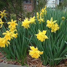
Mulching as NWRM is using organic material (e.g. bark, wood chips, grape pulp, shell nuts, green waste, leftover crops, compost, manure, straw, dry grass, leaves etc.) to cover the surface of the soil. It may be applied to bare soil, or around existing plants. Mulches of manure or compost will be incorporated naturally into the soil by the activity of worms and other organisms. The process is used both in commercial crop production and in gardening, and when applied correctly can dramatically improve the capacity of soil to store water.


Possible benefits with level
Benefits Level
BP2 - Slow runoff
High
BP6 - Increase infiltration and/or groundwater recharge
Low
BP7 - Increase soil water retention
Medium
BP10 - Reduce erosion and/or sediment delivery
Medium
ES6 - Groundwater/aquifer recharge
Medium
ES7 - Flood risk reduction
Medium
PO5 - Improving quantitative status
Low
PO8 - Prevent groundwater status deterioration
Low
PO9 - Take adequate and co-ordinated measures to reduce flood risks
Medium

Coarse woody debris

Code
F10
Sector
Forest
Other sector(s)
Agriculture
Urban
Hydro Morphology
The complete description of the NWRM
Summary

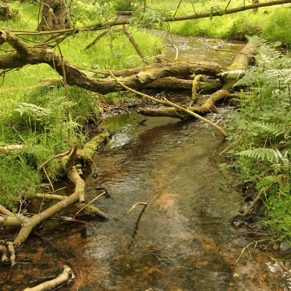
Coarse woody debris in stream channels has multiple ecological and hydrologic benefits. Coarse woody debris consists of large sections of deadfall: tree stems or stumps that either fall into or are deliberately placed in streams. Coarse woody debris can be deployed with varying degrees of naturalness. At one extreme, coarse woody debris can be used to form coffer or placer dams which effectively limit water flow. At the other extreme, natural deadfall coarse woody debris is found when riparian trees are allowed to fall naturally into streams. Coarse woody debris will generally slow water flow velocity and can reduce the peak of flood hydrographs. In addition to its role in slowing streamflow and facilitating sediment accumulation, coarse woody debris can improve aquatic biodiversity by retaining food and providing additional habitat, such as refuges and spawning sites.

Illustration(s)
Possible benefits with level
Benefits Level
BP3 - Store river water
Low
BP4 - Slow river water
High
BP10 - Reduce erosion and/or sediment delivery
Low
BP12 - Create aquatic habitat
High
BP13 - Create riparian habitat
Medium
ES2 - Fish stocks and recruiting
High
ES4 - Biodiversity preservation
High
ES7 - Flood risk reduction
Medium
ES8 - Erosion/sediment control
Low
ES10 - Recreational opportunities
Medium
PO1 - Improving status of biology quality elements
Medium
PO9 - Take adequate and co-ordinated measures to reduce flood risks
Medium
PO10 - Protection of important habitats
Medium
PO11 - Better protection for ecosystems and more use of Green Infrastructure
Medium
PO13 - Better management of fish stocks
Medium
PO14 - Prevention of biodiversity loss
Medium

Sediment capture ponds

Code
F09
Sector
Forest
Other sector(s)
Agriculture
Urban
Hydro Morphology
The complete description of the NWRM
Summary

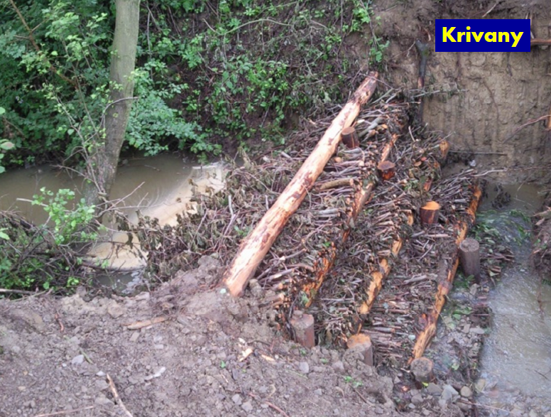
Sediment capture ponds are engineered ponds placed in networks of forest ditches to slow the velocity of water and cause the deposition of suspended materials. Sediment capture ponds are most useful for managing the effects of ditch construction and maintenance, road work and final feeling. While used primarily in forests, sediment capture ponds may be a useful temporary measure for preserving water quality in and around construction sites or mines.  They may also be useful for capturing sediment in agricultural runoff. Sediment capture ponds have a limited lifespan, depending on how much suspended material is in the inflowing water. However, ponds can be maintained by removal of accumulated sediment. As most water protection methods, sediment capture ponds function well during base and moderate flow events. Catchment area, hydraulic properties of ditches, discharge rate and soil characteristics are among factors influencing functioning of sedimentation capture ponds. Effective functioning largely depends also on expertise and skill of professionals designing and implementing this and also many other measures.

Illustration(s)

Sediment capture pond, Slovakia

Source: Michal Kravcík’s presentation, NWRM Workshop 1 (Slovakia)


Possible benefits with level
Benefits Level
BP1 - Store runoff
Medium
BP2 - Slow runoff
Medium
BP3 - Store river water
Low
BP4 - Slow river water
Low
BP6 - Increase infiltration and/or groundwater recharge
Low
BP7 - Increase soil water retention
Low
BP8 - Reduce pollutant sources
High
BP9 - Intercept pollution pathways
High
BP10 - Reduce erosion and/or sediment delivery
High
BP12 - Create aquatic habitat
Low
ES1 - Water storage
Medium
ES2 - Fish stocks and recruiting
High
ES4 - Biodiversity preservation
High
ES5 - Climate change adaptation and mitigation
Low
ES6 - Groundwater/aquifer recharge
Low
ES7 - Flood risk reduction
Medium
ES8 - Erosion/sediment control
High
ES9 - Filtration of pollutants
High
PO1 - Improving status of biology quality elements
Low
PO2 - Improving status of physico-chemical quality elements
Low
PO3 - Improving status of hydromorphology quality elements
Low
PO4 - Improving chemical status and priority substances
Low
PO7 - Prevent surface water status deterioration
High
PO9 - Take adequate and co-ordinated measures to reduce flood risks
Low
PO10 - Protection of important habitats
Low
PO11 - Better protection for ecosystems and more use of Green Infrastructure
Medium
PO12 - More sustainable agriculture and forestry
High
PO13 - Better management of fish stocks
Medium
PO14 - Prevention of biodiversity loss
Medium

Trees in Urban areas

Code
F12
Sector
Forest
Other sector(s)
Urban
The complete description of the NWRM
Summary

Trees in urban areas can have multiple benefits related to aesthetics, microclimate regulation and urban hydrology. Trees in urban areas can also be important biodiversity refuges and can contribute to reducing particulate air pollution. Trees intercept precipitation, reducing the amount of rainfall which must be processed by sewers and other water transporting infrastructure. The area around urban trees may also have greater infiltration capacity than the impermeable surfaces often found in urban areas. Trees also transpire, which dries the soil and gives greater capacity for rainfall storage.

Possible benefits with level
Benefits Level
BP1 - Store runoff
Medium
BP2 - Slow runoff
Medium
BP5 - Increase evapotranspiration
High
BP6 - Increase infiltration and/or groundwater recharge
Medium
BP7 - Increase soil water retention
Medium
BP8 - Reduce pollutant sources
Medium
BP9 - Intercept pollution pathways
High
BP10 - Reduce erosion and/or sediment delivery
Low
BP11 - Improve soils
Low
BP14 - Create terrestrial habitats
High
BP16 - Reduce peak temperature
High
BP17 - Absorb and/or retain CO2
High
ES1 - Water storage
Medium
ES3 - Natural biomass production
Medium
ES4 - Biodiversity preservation
High
ES5 - Climate change adaptation and mitigation
High
ES6 - Groundwater/aquifer recharge
Medium
ES7 - Flood risk reduction
Low
ES8 - Erosion/sediment control
Low
ES9 - Filtration of pollutants
High
ES10 - Recreational opportunities
High
ES11 - Aesthetic/cultural value
High
PO1 - Improving status of biology quality elements
Medium
PO5 - Improving quantitative status
Low
PO6 - Improving chemical status
Low
PO7 - Prevent surface water status deterioration
Low
PO8 - Prevent groundwater status deterioration
Low
PO9 - Take adequate and co-ordinated measures to reduce flood risks
Low
PO10 - Protection of important habitats
High
PO11 - Better protection for ecosystems and more use of Green Infrastructure
High
PO14 - Prevention of biodiversity loss
High

Urban forest parks

Code
F11
Sector
Forest
Other sector(s)
Urban
The complete description of the NWRM
Summary

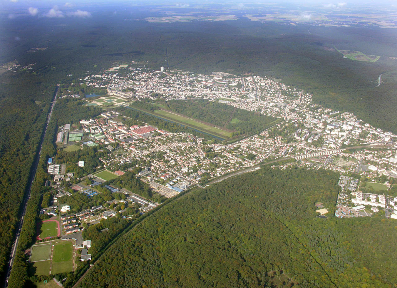
Urban forest parks can deliver a broad range of hydrology-related and other ecosystem services. Forests in urban areas have great amenity value, can improve air quality, moderate local microclimates, improve urban biodiversity and contribute to climate change mitigation as well as having ancillary hydrological benefits. Forest soils often have greater infiltration capacity than other urban land cover and can be an important location for aquifer recharge.

Illustration(s)

Aerial view of forest parks, France

Source: http://www.survoldefrance.fr/affichage2.php?img=3775&prev_suiv_link=1


Possible benefits with level
Benefits Level
BP1 - Store runoff
Medium
BP2 - Slow runoff
Medium
BP5 - Increase evapotranspiration
High
BP6 - Increase infiltration and/or groundwater recharge
High
BP7 - Increase soil water retention
High
BP8 - Reduce pollutant sources
High
BP9 - Intercept pollution pathways
High
BP10 - Reduce erosion and/or sediment delivery
Medium
BP11 - Improve soils
High
BP12 - Create aquatic habitat
Low
BP13 - Create riparian habitat
Low
BP14 - Create terrestrial habitats
High
BP15 - Enhance precipitation
Low
BP16 - Reduce peak temperature
High
BP17 - Absorb and/or retain CO2
High
ES1 - Water storage
Medium
ES2 - Fish stocks and recruiting
Low
ES3 - Natural biomass production
Medium
ES4 - Biodiversity preservation
High
ES5 - Climate change adaptation and mitigation
High
ES6 - Groundwater/aquifer recharge
Medium
ES7 - Flood risk reduction
Low
ES8 - Erosion/sediment control
Low
ES9 - Filtration of pollutants
Medium
ES10 - Recreational opportunities
High
ES11 - Aesthetic/cultural value
High
PO1 - Improving status of biology quality elements
Low
PO2 - Improving status of physico-chemical quality elements
Low
PO4 - Improving chemical status and priority substances
Low
PO5 - Improving quantitative status
Low
PO6 - Improving chemical status
Low
PO7 - Prevent surface water status deterioration
Medium
PO8 - Prevent groundwater status deterioration
Medium
PO9 - Take adequate and co-ordinated measures to reduce flood risks
Medium
PO10 - Protection of important habitats
High
PO11 - Better protection for ecosystems and more use of Green Infrastructure
High
PO13 - Better management of fish stocks
Low
PO14 - Prevention of biodiversity loss
High

Green Roofs

Code
U01
Sector
Urban
The complete description of the NWRM
Summary

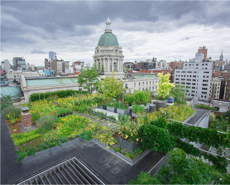
Green roofs are multi-layered systems that cover the roof of a building with vegetation and/or green landscaping over a drainage layer. There are two types of green roof:

  • Extensive green roofs cover the entire roof area with lightweight, low growing, self-sustaining, low maintenance planting. They are only accessed for maintenance. Vegetation normally consists of hardy, drought tolerant, succulents, herbs or grasses. Extensive green roofs are often known as sedum roofs, eco-roofs or living roofs.
  • Intensive green roofs are landscaped environments with high amenity benefits including accessible planters or trees and water features. These impose a greater load on the roof structure and require significant ongoing maintenance including irrigation, feeding and cutting. Intensive roofs are also termed roof gardens.

A typical structure for a green roof includes a surface vegetation layer underlain by a substrate (growth medium), geotextile filter layer, and an aggregate or geo-composite drainage layer. The green roof materials are underlain by a waterproof membrane, with an additional layer of insulation between that and the roof itself. Green roofs are designed to intercept rainfall, which is slowed as it flows through the vegetation and a drainage layer, mimicking the predevelopment state of the building footprint.

Some of the rainwater is stored in the drainage layer and taken up by the vegetation, with the remainder discharged from the roof in the normal way (via gutters and downpipes). Flow rates from the green roof are reduced and attenuated compared to a normal roof, and the total volumes discharged from the roof are also reduced. Green roofs therefore intercept rainfall at source and provide the first component of a SuDS management train.

Illustration(s)

Green roof

Source: Andras Kis’ presentation, NWRM Workshop 1

Possible benefits with level
Benefits Level
ES3 - Natural biomass production
Low
ES4 - Biodiversity preservation
Low
ES5 - Climate change adaptation and mitigation
Medium
ES7 - Flood risk reduction
Medium
ES9 - Filtration of pollutants
Low
ES10 - Recreational opportunities
Low
ES11 - Aesthetic/cultural value
Medium
PO2 - Improving status of physico-chemical quality elements
Low
PO4 - Improving chemical status and priority substances
Low
PO7 - Prevent surface water status deterioration
Low
PO9 - Take adequate and co-ordinated measures to reduce flood risks
Medium
PO11 - Better protection for ecosystems and more use of Green Infrastructure
Medium
PO14 - Prevention of biodiversity loss
Low
BP1 - Store runoff
Medium
BP2 - Slow runoff
Medium
BP5 - Increase evapotranspiration
High
BP8 - Reduce pollutant sources
Low
BP9 - Intercept pollution pathways
Low
BP14 - Create terrestrial habitats
Low
BP16 - Reduce peak temperature
Low
BP17 - Absorb and/or retain CO2
Low

Elimination of riverbank protection

Code
N11
Sector
Hydro Morphology
Other sector(s)
Urban
The complete description of the NWRM
Summary

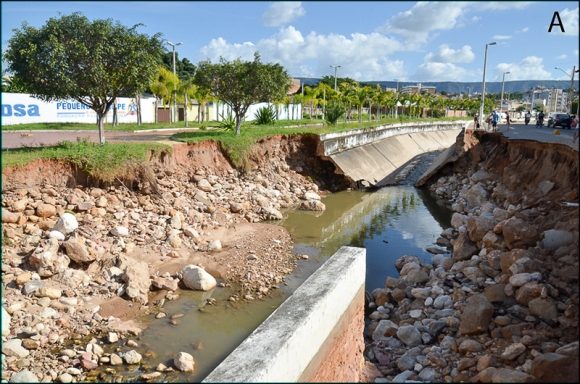
A riverbank protection is an inert or living construction providing bank fixation but also an obstacle for the lateral connection of the river. Eliminating it consists in removing some parts of the bank protection, especially the inert one, in order to enhance lateral connections of the river, diversify flows (depth, substrate, and speed) and habitats, but also cap floods in the mainstream. It is a prerequisite for many other measures like re-meandering or widening, as well as initiating later channel migration and dynamics.

This measure is appropriate and very efficient in impounded large gravel riverbeds where gravel bars are drowned and shallow low-velocity habitats are virtually absent. In these impounded rivers, spawning and nursery habitats like shallow near-bank gravel bars, side channels, and backwaters are often the bottleneck for stream-type specific fish species. River banks have been heavily fixed and the potential for river restoration is limited due to uses like navigation, hydropower or flood protection and mitigation measures are restricted to the river banks.

Illustration(s)

Destroyed artificial riverbank, (Brasil)

Source: http://echogeo.revues.org/13596?lang=en


Possible benefits with level
Benefits Level
PO1 - Improving status of biology quality elements
Medium
PO2 - Improving status of physico-chemical quality elements
Medium
PO3 - Improving status of hydromorphology quality elements
Medium
PO4 - Improving chemical status and priority substances
Medium
PO5 - Improving quantitative status
Low
PO6 - Improving chemical status
Low
PO7 - Prevent surface water status deterioration
Medium
PO8 - Prevent groundwater status deterioration
Low
PO9 - Take adequate and co-ordinated measures to reduce flood risks
Medium
PO10 - Protection of important habitats
High
PO11 - Better protection for ecosystems and more use of Green Infrastructure
High
PO12 - More sustainable agriculture and forestry
High
PO13 - Better management of fish stocks
High
PO14 - Prevention of biodiversity loss
High
ES1 - Water storage
Medium
ES2 - Fish stocks and recruiting
Medium
ES3 - Natural biomass production
Medium
ES4 - Biodiversity preservation
Medium
ES6 - Groundwater/aquifer recharge
Low
ES7 - Flood risk reduction
High
ES8 - Erosion/sediment control
Medium
ES9 - Filtration of pollutants
Medium
ES10 - Recreational opportunities
Medium
ES11 - Aesthetic/cultural value
Medium
BP1 - Store runoff
Low
BP2 - Slow runoff
Low
BP3 - Store river water
High
BP4 - Slow river water
High
BP5 - Increase evapotranspiration
Low
BP6 - Increase infiltration and/or groundwater recharge
Low
BP7 - Increase soil water retention
Low
BP9 - Intercept pollution pathways
Medium
BP10 - Reduce erosion and/or sediment delivery
Medium
BP12 - Create aquatic habitat
Medium
BP13 - Create riparian habitat
Medium
BP17 - Absorb and/or retain CO2
Low

Soakaways

Code
U07
Sector
Urban
Other sector(s)
Agriculture
The complete description of the NWRM
Summary

Soakaways are buried chambers that store surface water and allow it to soak into the ground. They are typically square or circular excavations either filled with rubble or lined with brickwork, pre-cast concrete or polyethylene rings/perforated storage structures surrounded by granular backfill. The supporting structure and backfill can be substituted by modular, geocellular units. 

Soakaways provide storm water attenuation, and storm water treatment. They also increase soil moisture content and help to recharge groundwater, thereby offering the potential to mitigate problems of low river flows. They store rapid runoff from a single house or from a development and allow its efficient infiltration into the surrounding soil. They can also be used to manage overflows from water butts and other rainwater collection systems, or can be linked together to drain larger areas including highways.

As a sub-surface infiltration device, a soakaway requires no net land take. They can be built in many shapes and can often be accommodated within high-density urban developments, and can also be retro-fitted. Soakaways are easy to integrate into a site, but offer very little amenity or biodiversity value as they are underground features and water should not appear on the surface.

Illustration(s)

Principle of a soakaway

Source: Andras Kis’ presentation, NWRM Workshop 1


Possible benefits with level
Benefits Level
ES1 - Water storage
Low
ES5 - Climate change adaptation and mitigation
Low
ES6 - Groundwater/aquifer recharge
High
ES7 - Flood risk reduction
High
ES9 - Filtration of pollutants
Low
PO2 - Improving status of physico-chemical quality elements
Low
PO4 - Improving chemical status and priority substances
Low
PO5 - Improving quantitative status
Medium
PO7 - Prevent surface water status deterioration
Low
PO8 - Prevent groundwater status deterioration
Low
PO9 - Take adequate and co-ordinated measures to reduce flood risks
High
PO11 - Better protection for ecosystems and more use of Green Infrastructure
Low
BP1 - Store runoff
Medium
BP6 - Increase infiltration and/or groundwater recharge
High
BP7 - Increase soil water retention
Low
BP8 - Reduce pollutant sources
Low
BP9 - Intercept pollution pathways
Low

Channels and rills

Code
U05
Sector
Urban
Other sector(s)
Agriculture
The complete description of the NWRM
Summary

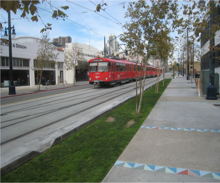
Channels and rills are shallow open surface water channels incorporated in to the start of a SuDS train. They collect water, slow it down and provide storage for silt deposited from runoff. They can have a variety of cross sections to suit the urban landscape, and can include the use of planting to provide both enhanced visual appeal and water treatment.

The main role of channels and rills are to capture runoff at the start of a SuDS train, allow deposition of sediment and convey the runoff to downstream SuDS features.  They can also be used in between SuDS features as connectors.  They collect water, slow it down and provide storage for silt and oil that is captured. The outlets are designed to act as a mini oil separator, making them effective at treating pollution and reducing treatment requirements downstream. Clearly channels can be included in many situations and settings, but would not always considered to be NWRMs unless specifically designed to perform these functions and used in conjunction with other measures.

Planting in channels and rills can visually enhance the urban landscape and offer biodiversity and amenity value. These features can be applied to all new developments and can be retrofitted to existing developments.

Illustration(s)

Channel in urban area

Source: http://www.susdrain.org/delivering-suds/using-suds/suds-components/swales-and-conveyance-channels/channels-and-rills.html

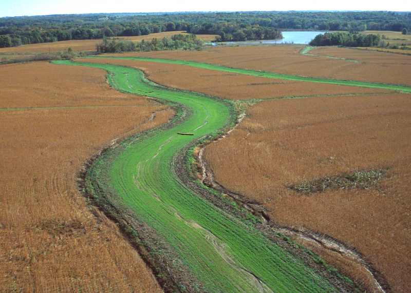
Rill in urban area

Source: Andras Kis’ presentation,
NWRM Workshop 1

Possible benefits with level
Benefits Level
ES3 - Natural biomass production
Low
ES4 - Biodiversity preservation
Low
ES5 - Climate change adaptation and mitigation
Low
ES7 - Flood risk reduction
Low
ES8 - Erosion/sediment control
Low
ES9 - Filtration of pollutants
Low
ES11 - Aesthetic/cultural value
Medium
PO9 - Take adequate and co-ordinated measures to reduce flood risks
Low
PO11 - Better protection for ecosystems and more use of Green Infrastructure
Low
PO14 - Prevention of biodiversity loss
Low
BP1 - Store runoff
Low
BP2 - Slow runoff
Medium
BP5 - Increase evapotranspiration
Medium
BP6 - Increase infiltration and/or groundwater recharge
Low
BP9 - Intercept pollution pathways
Medium
BP10 - Reduce erosion and/or sediment delivery
Low
BP12 - Create aquatic habitat
Low
BP14 - Create terrestrial habitats
Low
BP16 - Reduce peak temperature
Low
BP17 - Absorb and/or retain CO2
Low

Swales

Code
U04
Sector
Urban
Other sector(s)
Agriculture
The complete description of the NWRM
Summary

Swales are broad, shallow, linear vegetated channels which can store or convey surface water (reducing runoff rates and volumes) and remove pollutants. They can be used as conveyance features to pass the runoff to the next stage of the SuDS treatment train and can be designed to promote infiltration where soil and groundwater conditions allow. Three kinds of swale give different surface water management capabilities:

  • Standard conveyance swale – Generally used to convey runoff from the drainage catchment to another stage of a SuDS train.  They may be lined or un-lined, depending on the suitability for infiltration.
  • Enhanced dry swale – Includes an underdrain filter bed of soil beneath the vegetated conveyance channel to accommodate extra treatment and conveyance capacity above that of the standard swale.  The underdrain leaves the main channel dry except for larger runoff events, and will prevent channels becoming waterlogged where the swale is situated on gentler slopes. A lining can also be incorporated into the underdrain if infiltration to underlying ground is not appropriate.
  • Wet swale - Where prolonged treatment processes are required for the storm runoff, the swale’s conveyance channel can be encouraged to maintain marshy conditions by using liners to control infiltration, or by siting in an area with high water table.

The promotion of settling is enhanced by the use of dense vegetation, usually grass, which promotes low flow velocities to trap particulate pollutants.  In addition, check dams or berms can be installed across the swale channel to promote settling and infiltration. As a result, swales are effective in improving water quality of runoff, by removing sediment and particulate pollutants. In wet swales, the effectiveness is further enhanced by providing permanent wetland conditions on the base of the swale.

Swales are applicable to a wide range of situations. They are typically located next to roads, where they replace conventional gullies and drainage pipe systems, but examples can also be seen of swales being located in landscaped areas, adjacent to car parks, alongside fields, and in other open spaces. They are ideal for use as drainage systems on industrial sites because any pollution that occurs is visible and can be dealt with before it causes damage to the receiving watercourse. 

Illustration(s)

Swale

Source: Andras Kis’ presentation, NWRM Workshop 1


Possible benefits with level
Benefits Level
ES1 - Water storage
Low
ES3 - Natural biomass production
Low
ES4 - Biodiversity preservation
Medium
ES5 - Climate change adaptation and mitigation
Medium
ES6 - Groundwater/aquifer recharge
Medium
ES7 - Flood risk reduction
Medium
ES8 - Erosion/sediment control
Low
ES9 - Filtration of pollutants
Medium
ES11 - Aesthetic/cultural value
Medium
PO2 - Improving status of physico-chemical quality elements
Low
PO4 - Improving chemical status and priority substances
Low
PO5 - Improving quantitative status
Low
PO7 - Prevent surface water status deterioration
Medium
PO8 - Prevent groundwater status deterioration
Low
PO9 - Take adequate and co-ordinated measures to reduce flood risks
High
PO11 - Better protection for ecosystems and more use of Green Infrastructure
Medium
PO12 - More sustainable agriculture and forestry
Low
PO14 - Prevention of biodiversity loss
Medium
BP1 - Store runoff
Medium
BP2 - Slow runoff
High
BP5 - Increase evapotranspiration
Medium
BP6 - Increase infiltration and/or groundwater recharge
Medium
BP7 - Increase soil water retention
Low
BP8 - Reduce pollutant sources
Low
BP9 - Intercept pollution pathways
Medium
BP10 - Reduce erosion and/or sediment delivery
Medium
BP13 - Create riparian habitat
Low
BP14 - Create terrestrial habitats
Low
BP16 - Reduce peak temperature
Low
BP17 - Absorb and/or retain CO2
Low

Partners

Logos of all partners of NWRM project