Restoration of natural infiltration to groundwater

Code
N13
Sector
Hydro Morphology
Summary

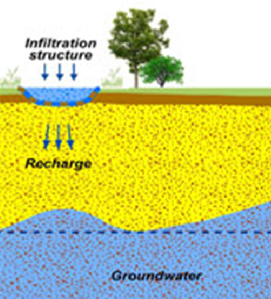
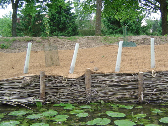
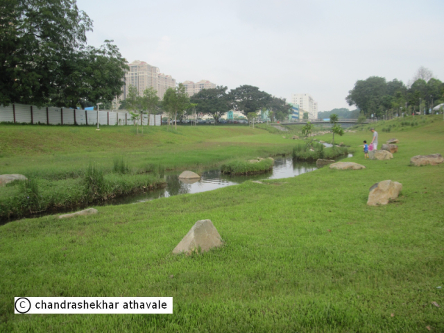
Groundwater is the part of infiltrated water which composes the water resource for population and human activities.  Previous modifications of the landscape have reduced the infiltration capacity of many European soils, thereby limiting the rate at which precipitation is able to infiltrate and recharge groundwater aquifers. Restoration of natural infiltration to groundwater enables a lowering of run-off from surrounding land, and...

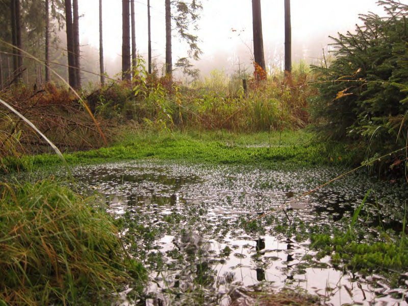
Explicative scheme of enhanced infiltration (UK)

Source: http://www.bgs.ac.uk/research/groundwater/agrar.html

Possible benefits with level
Benefits Level
PO5 - Improving quantitative status
Medium
PO8 - Prevent groundwater status deterioration
Medium
PO9 - Take adequate and co-ordinated measures to reduce flood risks
Low
ES1 - Water storage
Medium
ES5 - Climate change adaptation and mitigation
Low
ES6 - Groundwater/aquifer recharge
Medium
ES7 - Flood risk reduction
Low
ES8 - Erosion/sediment control
Low
ES13 - Geological resources
High
BP1 - Store runoff
Low
BP2 - Slow runoff
Medium
BP6 - Increase infiltration and/or groundwater recharge
High
BP7 - Increase soil water retention
Medium
BP9 - Intercept pollution pathways
Low
BP10 - Reduce erosion and/or sediment delivery
Low

Detention Basins

Code
U10
Sector
Urban
Other sector(s)
Agriculture
Forest
Hydro Morphology
The complete description of the NWRM
Summary

Detention basins are vegetated depressions designed to hold runoff from impermeable surfaces and allow the settling of sediments and associated pollutants. Stored water may be slowly drained to a nearby watercourse, using an outlet control structure to control the flow rate. Detention basins do not generally allow infiltration: see U12 for infiltration basins.

Detention basins can provide water...

Infiltration basin

Source: Andras Kis’ presentation, NWRM Workshop 1


Possible benefits with level
Benefits Level
ES1 - Water storage
Medium
ES3 - Natural biomass production
Low
ES4 - Biodiversity preservation
Medium
ES5 - Climate change adaptation and mitigation
Medium
ES6 - Groundwater/aquifer recharge
Low
ES7 - Flood risk reduction
High
ES8 - Erosion/sediment control
Medium
ES9 - Filtration of pollutants
Medium
ES10 - Recreational opportunities
Medium
ES11 - Aesthetic/cultural value
Medium
PO2 - Improving status of physico-chemical quality elements
Low
PO4 - Improving chemical status and priority substances
Low
PO7 - Prevent surface water status deterioration
Medium
PO9 - Take adequate and co-ordinated measures to reduce flood risks
High
PO11 - Better protection for ecosystems and more use of Green Infrastructure
High
PO12 - More sustainable agriculture and forestry
Low
PO14 - Prevention of biodiversity loss
Medium
BP1 - Store runoff
High
BP2 - Slow runoff
High
BP5 - Increase evapotranspiration
Medium
BP6 - Increase infiltration and/or groundwater recharge
Low
BP7 - Increase soil water retention
Low
BP9 - Intercept pollution pathways
Medium
BP10 - Reduce erosion and/or sediment delivery
Medium
BP14 - Create terrestrial habitats
Medium
BP16 - Reduce peak temperature
Low
BP17 - Absorb and/or retain CO2
Low

Retention Ponds

Code
U11
Sector
Urban
Other sector(s)
Agriculture
Forest
Hydro Morphology
The complete description of the NWRM
Summary

Retention ponds are ponds or pools designed with additional storage capacity to attenuate surface runoff during rainfall events.  They consist of a permanent pond area with landscaped banks and surroundings to provide additional storage capacity during rainfall events.  They are created by using an existing natural depression, by excavating a new depression, or by constructing embankments.  Existing natural...

Possible benefits with level
Benefits Level
ES1 - Water storage
Medium
ES3 - Natural biomass production
Medium
ES4 - Biodiversity preservation
High
ES5 - Climate change adaptation and mitigation
Medium
ES7 - Flood risk reduction
High
ES8 - Erosion/sediment control
Medium
ES9 - Filtration of pollutants
High
ES10 - Recreational opportunities
Medium
ES11 - Aesthetic/cultural value
High
PO2 - Improving status of physico-chemical quality elements
Low
PO4 - Improving chemical status and priority substances
Low
PO7 - Prevent surface water status deterioration
Medium
PO9 - Take adequate and co-ordinated measures to reduce flood risks
High
PO11 - Better protection for ecosystems and more use of Green Infrastructure
High
PO12 - More sustainable agriculture and forestry
Low
PO14 - Prevention of biodiversity loss
High
BP1 - Store runoff
High
BP2 - Slow runoff
High
BP5 - Increase evapotranspiration
Medium
BP8 - Reduce pollutant sources
Low
BP9 - Intercept pollution pathways
High
BP10 - Reduce erosion and/or sediment delivery
High
BP12 - Create aquatic habitat
High
BP13 - Create riparian habitat
Medium
BP14 - Create terrestrial habitats
Low
BP15 - Enhance precipitation
Low
BP16 - Reduce peak temperature
Low

Infiltration basins

Code
U12
Sector
Urban
Other sector(s)
Agriculture
Forest
Hydro Morphology
The complete description of the NWRM
Summary

Infiltration basins are vegetated depressions designed to hold runoff from impervious surfaces, allow the settling of sediments and associated pollutants, and allow water to infiltrate into underlying soils and groundwater. Infiltration basins are dry except in periods of heavy rainfall, and may serve other functions (e.g. recreation). They provide runoff storage and flow control as part of a SuDS ‘train’. Storage is provided through...

Explicative scheme of the MAR principle

Source: Andras Kis’ presentation, NWRM Workshop 1


Possible benefits with level
Benefits Level
ES1 - Water storage
Medium
ES3 - Natural biomass production
Low
ES4 - Biodiversity preservation
Medium
ES5 - Climate change adaptation and mitigation
Medium
ES6 - Groundwater/aquifer recharge
High
ES7 - Flood risk reduction
High
ES8 - Erosion/sediment control
Low
ES9 - Filtration of pollutants
High
ES10 - Recreational opportunities
Medium
ES11 - Aesthetic/cultural value
Medium
PO2 - Improving status of physico-chemical quality elements
Low
PO4 - Improving chemical status and priority substances
Low
PO5 - Improving quantitative status
Medium
PO7 - Prevent surface water status deterioration
Medium
PO8 - Prevent groundwater status deterioration
Low
PO9 - Take adequate and co-ordinated measures to reduce flood risks
High
PO11 - Better protection for ecosystems and more use of Green Infrastructure
High
PO12 - More sustainable agriculture and forestry
Low
PO14 - Prevention of biodiversity loss
Medium
BP1 - Store runoff
High
BP2 - Slow runoff
High
BP5 - Increase evapotranspiration
Low
BP6 - Increase infiltration and/or groundwater recharge
High
BP7 - Increase soil water retention
Low
BP9 - Intercept pollution pathways
High
BP10 - Reduce erosion and/or sediment delivery
Medium
BP14 - Create terrestrial habitats
Medium
BP16 - Reduce peak temperature
Low
BP17 - Absorb and/or retain CO2
Low

Natural bank stabilisation

Code
N10
Sector
Hydro Morphology
Other sector(s)
Urban
The complete description of the NWRM
Summary

Riverbank represents both natural and artificial terrain following the river flow. In the past, lots of artificial banks were built with concrete or other types of retention walls, therefore limiting rivers’ natural movements, leading to degradation of the river, increased water flow, increased erosion and decreased biodiversity. River bank renaturalisation consists in recovering its ecological components, thus reversing such damages and...

Bank stabilisation with stones (USA)

Source: http://www.goldenvalleymn.gov/surfacewater/stream-bank-stabilization.php

Bank stabilisation with wood weaving (France)

Source: http://www.siave.net/Protections_berges.html

Possible benefits with level
Benefits Level
BP1 - Store runoff
Low
BP2 - Slow runoff
Low
BP3 - Store river water
Low
BP4 - Slow river water
Medium
BP5 - Increase evapotranspiration
Medium
BP6 - Increase infiltration and/or groundwater recharge
Low
BP7 - Increase soil water retention
Medium
BP8 - Reduce pollutant sources
Low
BP9 - Intercept pollution pathways
Medium
BP10 - Reduce erosion and/or sediment delivery
High
BP11 - Improve soils
High
BP12 - Create aquatic habitat
High
BP13 - Create riparian habitat
High
BP14 - Create terrestrial habitats
Low
BP16 - Reduce peak temperature
Low
BP17 - Absorb and/or retain CO2
Low
ES1 - Water storage
Low
ES2 - Fish stocks and recruiting
High
ES3 - Natural biomass production
High
ES4 - Biodiversity preservation
High
ES5 - Climate change adaptation and mitigation
Low
ES6 - Groundwater/aquifer recharge
Low
ES7 - Flood risk reduction
Medium
ES8 - Erosion/sediment control
High
ES9 - Filtration of pollutants
High
ES10 - Recreational opportunities
High
ES11 - Aesthetic/cultural value
High
PO1 - Improving status of biology quality elements
High
PO2 - Improving status of physico-chemical quality elements
Medium
PO3 - Improving status of hydromorphology quality elements
High
PO4 - Improving chemical status and priority substances
Medium
PO5 - Improving quantitative status
Low
PO6 - Improving chemical status
Low
PO7 - Prevent surface water status deterioration
High
PO8 - Prevent groundwater status deterioration
Low
PO9 - Take adequate and co-ordinated measures to reduce flood risks
Medium
PO10 - Protection of important habitats
High
PO11 - Better protection for ecosystems and more use of Green Infrastructure
High
PO12 - More sustainable agriculture and forestry
High
PO13 - Better management of fish stocks
High
PO14 - Prevention of biodiversity loss
High

Floodplain restoration and management

Code
N03
Sector
Hydro Morphology
The complete description of the NWRM
Summary

A floodplain is the area bordering a river that naturally provides space for the retention of flood and rainwater.  Floodplain soils are generally very fertile and they have often been dried-out to be used as agricultural land. Floodplains in many places have also been separated from the river by dikes, berms or other structures designed to control the flow of the river. They have also been covered by legacy sediments.

Major...

Floodplain before flooding

Source: Thomas Borchers’ presentation,
NWRM Workshop 1 (from: Christian Damm)

Floodplain during flooding

Source: Thomas Borchers’ presentation, NWRM Workshop 1 (from: Nora Künkler)

Possible benefits with level
Benefits Level
BP1 - Store runoff
High
BP2 - Slow runoff
High
BP3 - Store river water
High
BP4 - Slow river water
High
BP5 - Increase evapotranspiration
Medium
BP6 - Increase infiltration and/or groundwater recharge
High
BP7 - Increase soil water retention
Medium
BP8 - Reduce pollutant sources
Medium
BP9 - Intercept pollution pathways
Medium
BP10 - Reduce erosion and/or sediment delivery
High
BP11 - Improve soils
High
BP12 - Create aquatic habitat
Medium
BP13 - Create riparian habitat
High
BP14 - Create terrestrial habitats
High
BP15 - Enhance precipitation
Low
BP16 - Reduce peak temperature
Medium
BP17 - Absorb and/or retain CO2
Medium
ES1 - Water storage
High
ES2 - Fish stocks and recruiting
High
ES3 - Natural biomass production
High
ES4 - Biodiversity preservation
High
ES5 - Climate change adaptation and mitigation
Medium
ES6 - Groundwater/aquifer recharge
High
ES7 - Flood risk reduction
High
ES8 - Erosion/sediment control
High
ES9 - Filtration of pollutants
Medium
ES10 - Recreational opportunities
High
ES11 - Aesthetic/cultural value
High
PO1 - Improving status of biology quality elements
High
PO2 - Improving status of physico-chemical quality elements
High
PO3 - Improving status of hydromorphology quality elements
High
PO4 - Improving chemical status and priority substances
Medium
PO5 - Improving quantitative status
Medium
PO6 - Improving chemical status
Medium
PO7 - Prevent surface water status deterioration
High
PO8 - Prevent groundwater status deterioration
Medium
PO9 - Take adequate and co-ordinated measures to reduce flood risks
High
PO10 - Protection of important habitats
High
PO11 - Better protection for ecosystems and more use of Green Infrastructure
High
PO12 - More sustainable agriculture and forestry
High
PO13 - Better management of fish stocks
High
PO14 - Prevention of biodiversity loss
High
ES5 - Climate change adaptation and mitigation
Low

Re-meandering

Code
N04
Sector
Hydro Morphology
The complete description of the NWRM
Summary

A river meander is a U-form taken by the river, allowing it to decrease water velocity. In the past, rivers have been straightened by cutting off meanders. Many rivers in northern and Western Europe have been straightened and channelized to, for example, facilitate log floating and/or speed up the drainage of water and control/limit the river bed movements. Channelizing was also a way to gain land for cultivation. River re-meandering consists...

River before re-meandering

River after re-meandering

Source: http://riverwatch.eu/en/the-morava-anniversary-project-2014

Possible benefits with level
Benefits Level
PO1 - Improving status of biology quality elements
High
PO2 - Improving status of physico-chemical quality elements
High
PO3 - Improving status of hydromorphology quality elements
High
PO4 - Improving chemical status and priority substances
Medium
PO5 - Improving quantitative status
Medium
PO6 - Improving chemical status
Medium
PO7 - Prevent surface water status deterioration
High
PO8 - Prevent groundwater status deterioration
Medium
PO9 - Take adequate and co-ordinated measures to reduce flood risks
High
PO10 - Protection of important habitats
High
PO11 - Better protection for ecosystems and more use of Green Infrastructure
High
PO12 - More sustainable agriculture and forestry
High
PO13 - Better management of fish stocks
High
PO14 - Prevention of biodiversity loss
High
ES1 - Water storage
Medium
ES2 - Fish stocks and recruiting
Medium
ES3 - Natural biomass production
High
ES4 - Biodiversity preservation
High
ES5 - Climate change adaptation and mitigation
Medium
ES6 - Groundwater/aquifer recharge
High
ES7 - Flood risk reduction
High
ES8 - Erosion/sediment control
High
ES9 - Filtration of pollutants
Medium
ES10 - Recreational opportunities
High
ES11 - Aesthetic/cultural value
High
BP1 - Store runoff
Medium
BP2 - Slow runoff
Medium
BP3 - Store river water
Medium
BP4 - Slow river water
High
BP5 - Increase evapotranspiration
Low
BP6 - Increase infiltration and/or groundwater recharge
Medium
BP7 - Increase soil water retention
Medium
BP8 - Reduce pollutant sources
Low
BP9 - Intercept pollution pathways
High
BP10 - Reduce erosion and/or sediment delivery
High
BP11 - Improve soils
Medium
BP12 - Create aquatic habitat
High
BP13 - Create riparian habitat
High
BP14 - Create terrestrial habitats
Medium
BP16 - Reduce peak temperature
Medium
BP17 - Absorb and/or retain CO2
Low

Stream bed re-naturalization

Code
N05
Sector
Hydro Morphology
Other sector(s)
Urban
The complete description of the NWRM
Summary

Streambed (or riverbed) represents the floor of the river, including each riverbank. In the past, riverbeds were artificially reconstructed with concrete or big stones, therefore modifying flows and decreasing fauna habitat and vegetation diversity. Those modifications were aiming at flood prevention or supporting changes of agricultural practices for example. This has led to uniformed flows in the rivers and often having effect of reducing...

Possible benefits with level
Benefits Level
BP3 - Store river water
Medium
BP4 - Slow river water
High
BP5 - Increase evapotranspiration
Low
BP6 - Increase infiltration and/or groundwater recharge
High
BP7 - Increase soil water retention
Low
BP9 - Intercept pollution pathways
Medium
BP10 - Reduce erosion and/or sediment delivery
High
BP11 - Improve soils
Medium
BP12 - Create aquatic habitat
High
BP13 - Create riparian habitat
High
BP14 - Create terrestrial habitats
Low
BP16 - Reduce peak temperature
Medium
BP17 - Absorb and/or retain CO2
Low
ES1 - Water storage
Low
ES2 - Fish stocks and recruiting
Low
ES3 - Natural biomass production
Medium
ES4 - Biodiversity preservation
High
ES6 - Groundwater/aquifer recharge
Low
ES7 - Flood risk reduction
Medium
ES8 - Erosion/sediment control
High
ES9 - Filtration of pollutants
Medium
ES10 - Recreational opportunities
Medium
ES11 - Aesthetic/cultural value
Medium
PO1 - Improving status of biology quality elements
High
PO2 - Improving status of physico-chemical quality elements
Low
PO3 - Improving status of hydromorphology quality elements
Medium
PO4 - Improving chemical status and priority substances
Medium
PO5 - Improving quantitative status
Low
PO6 - Improving chemical status
Low
PO7 - Prevent surface water status deterioration
Medium
PO8 - Prevent groundwater status deterioration
Medium
PO9 - Take adequate and co-ordinated measures to reduce flood risks
Medium
PO10 - Protection of important habitats
High
PO11 - Better protection for ecosystems and more use of Green Infrastructure
High
PO13 - Better management of fish stocks
High
PO14 - Prevention of biodiversity loss
High

Wetland restoration and management

Code
N02
Sector
Hydro Morphology
Other sector(s)
Agriculture
Urban
Forest
The complete description of the NWRM
Summary

According to the Convention on Wetlands (1971), a wetland is an area of marsh, fen, peatland or water, whether natural or artificial, permanent or temporary, with water that is static or flowing, fresh, brackish or salt, including areas of marine water the depth of which at low tide does not exceed six metres. It provides water retention, biodiversity enhancement or water quality improvement.


Wetland restoration and...


Wetland in a forest

Source: Gebhard Schueler’s presentation, NWRM Workshop 1

Possible benefits with level
Benefits Level
BP1 - Store runoff
High
BP2 - Slow runoff
High
BP3 - Store river water
Medium
BP4 - Slow river water
Medium
BP6 - Increase infiltration and/or groundwater recharge
Medium
BP7 - Increase soil water retention
Medium
BP9 - Intercept pollution pathways
Medium
BP10 - Reduce erosion and/or sediment delivery
Low
BP11 - Improve soils
Low
BP12 - Create aquatic habitat
High
BP13 - Create riparian habitat
High
BP14 - Create terrestrial habitats
Low
BP17 - Absorb and/or retain CO2
High
PO1 - Improving status of biology quality elements
High
PO2 - Improving status of physico-chemical quality elements
Medium
PO3 - Improving status of hydromorphology quality elements
Low
PO5 - Improving quantitative status
Medium
PO7 - Prevent surface water status deterioration
Medium
PO8 - Prevent groundwater status deterioration
Medium
PO9 - Take adequate and co-ordinated measures to reduce flood risks
Medium
PO10 - Protection of important habitats
High
PO11 - Better protection for ecosystems and more use of Green Infrastructure
High
PO12 - More sustainable agriculture and forestry
Low
PO13 - Better management of fish stocks
High
PO14 - Prevention of biodiversity loss
High
ES1 - Water storage
Medium
ES2 - Fish stocks and recruiting
High
ES3 - Natural biomass production
Medium
ES4 - Biodiversity preservation
High
ES5 - Climate change adaptation and mitigation
Medium
ES6 - Groundwater/aquifer recharge
Medium
ES7 - Flood risk reduction
Medium
ES8 - Erosion/sediment control
Low
ES9 - Filtration of pollutants
Medium
ES10 - Recreational opportunities
Medium
ES11 - Aesthetic/cultural value
Medium
Case study(ies)

Buffer strips and hedges

Code
A02
Sector
Agriculture
Other sector(s)
Urban
Forest
Hydro Morphology
The complete description of the NWRM
Summary

Buffer strips are areas of natural vegetation cover (grass, bushes or trees) at the margin of fields, arable land, transport infrastructures and water courses. They can have several different configurations of vegetation found on them varying from simply grass to combinations of grass, trees, and shrubs.  Due to their permanent vegetation, buffer strips offer good conditions for effective water infiltration and slowing surface flow; they...

Possible benefits with level
Benefits Level
BP2 - Slow runoff
High
BP5 - Increase evapotranspiration
Medium
BP6 - Increase infiltration and/or groundwater recharge
Low
BP7 - Increase soil water retention
Medium
BP9 - Intercept pollution pathways
Medium
BP10 - Reduce erosion and/or sediment delivery
High
BP11 - Improve soils
Low
BP14 - Create terrestrial habitats
Medium
BP17 - Absorb and/or retain CO2
Medium
ES3 - Natural biomass production
Low
ES4 - Biodiversity preservation
Low
ES5 - Climate change adaptation and mitigation
Medium
ES6 - Groundwater/aquifer recharge
Medium
ES7 - Flood risk reduction
High
ES8 - Erosion/sediment control
High
ES9 - Filtration of pollutants
High
PO1 - Improving status of biology quality elements
Low
PO2 - Improving status of physico-chemical quality elements
Low
PO3 - Improving status of hydromorphology quality elements
Medium
PO4 - Improving chemical status and priority substances
Low
PO5 - Improving quantitative status
Low
PO6 - Improving chemical status
Low
PO7 - Prevent surface water status deterioration
High
PO8 - Prevent groundwater status deterioration
Medium
PO9 - Take adequate and co-ordinated measures to reduce flood risks
High
PO10 - Protection of important habitats
Low
PO11 - Better protection for ecosystems and more use of Green Infrastructure
High
PO12 - More sustainable agriculture and forestry
High
PO13 - Better management of fish stocks
Low
PO14 - Prevention of biodiversity loss
High